
Watershed Model
Related Research
EPRI researchers routinely collaborate to address complex, inter-related issues associated with water & air quality in the United States. The following EPRI projects represent work that relates to and supports the Ohio River Basin Trading Project.
- Water Quality and Watershed Protection

- Water Availability and Resource Risk Management
- Effluent Guidelines and Water Quality Management
- Global Energy and Climate Policy Costs & Benefits
- Air Quality Assessment of Ozone, Particulate Matter, Visibility, and Deposition
- Developing GHG Emissions Offsets by Reducing Nitrous Oxide Emissions in Agricultural Crop Production: Experience Validating a
New GHG Offset Protocol
- EPRI Water Prism Decision Support System
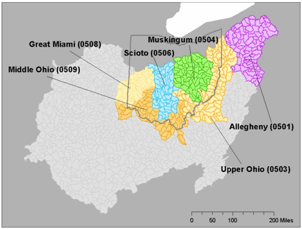 Figure 1: Ohio River Basin (light
grey) with HUC 4 Watersheds Calibrated with WARMF Model highlighted
Figure 1: Ohio River Basin (light
grey) with HUC 4 Watersheds Calibrated with WARMF Model highlightedThe Ohio River Basin Water Quality Trading Project utilizes two models for estimating nutrient reductions from the point of generation (credit seller) to the point of use (credit buyer). The models account for location-specific nutrient attenuation factors and ensure that the Project pays for performance, i.e. nutrient reductions, not simply conservation practices. The Project is currently using: (1) the EPA Region 5 spreadsheet model for estimating nutrient reductions at the edge of the field (i.e., Point of Generation Credits); and (2) the Watershed Analysis Risk Management Framework (WARMF) model for estimating nutrient attenuation (reduction) from the edge-of-field to the point of use (i.e., Point of Use Credits). The Project is also testing the USDA Natural Resources Conservation Service (“NRCS”)-developed Nutrient Tracking Tool as an edge-of-field calculator, and we continue to monitor opportunities to improve the technical basis for estimating edge of field loadings.
The WARMF model is applied to predict the in-stream responses to nutrient load reductions between credit sellers and credit buyers, thereby estimating the total nutrient reductions actually achieved at any particular point of compliance. These predictions account for a number of physical factors (e.g., location of buyer and seller, in-stream fate and transport, specific form of pollutant), as well as the uncertainty inherent in the model itself. In this way, the project calculates unique trade ratios for every single transaction, and accounts for the unique watershed characteristics present between each buyer and seller. The project does not use an overarching trade ratio, but rather, specific ratios that account for the slope, soil type, river dynamics, and specific nutrient assimilation capacity between each buyer and seller.
Under funding from USDA and EPA, the Project collaborated with the University of California Santa Barbara to calibrate the WARMF model in six HUC 4 watersheds (shown above) with observational data. The nutrient load attenuation factors were developed for total nitrogen (TN) and total phosphorus (TP) for each of the watersheds in the Project pilot area. More results of the model calibration can be found in the EPRI report (1025820) “Implementation of the Watershed Analysis Risk Management Framework (WARMF) Watershed Model for Nutrient Trading in the Ohio River Basin.”
Background on the Watershed Analysis Risk Management Framework (WARMF) Model
WARMF has been implemented in over 30 watersheds throughout the United States and abroad, and is available for download directly from EPA. The model is used for decision-support in watershed management and for regulatory activities, specifically in the development of Total Maximum Daily Loads (TMDLs). Water from precipitation, as rainfall or snowfall, is routed through the canopy, land surface, shallow subsurface flow and deep groundwater flow to receiving water bodies (streams, rivers or lakes), taking into consideration losses due to evapotranspiration, irrigation and other extractive uses which may not return it to the system. Chemicals are (1) in the system initially (for example, nitrogen in vegetation, groundwater and/or soil minerals); (2) applied to the land surface (for example, fertilization, irrigation water, atmospheric deposition, septic system discharge, animal waste); and/or (3) are discharged directly into a water body (for example, discharge of treated effluent). Assimilation and transformation among nitrogen species and phosphorus cycling dynamics is simulated on the soil surface or in the various water compartments.
The engineering module of WARMF contains a dynamic watershed simulation tool that calculates daily surface runoff, groundwater flow, non-point source loads, hydrology, and water quality of river segments and stratified reservoirs. In the model, a watershed is divided into a network of land catchments, river segments, and reservoir layers. Land catchments are further divided into land surface and soil layers. These watershed compartments are seamlessly connected for hydrologic and water quality simulations. The land surface is characterized by its land uses and cover, which may include rain and snow that is deposited on the land catchments. The model performs daily simulations of snow and soil hydrology to calculate surface runoff and groundwater accretion to river segments. The water is then routed from one river segment to the next downstream river segment until it reaches the terminus of the watershed. The associated point and nonpoint loads are also routed through the system. Heat budget and mass balance calculations are performed to calculate the temperature and concentrations of various water quality constituents in each soil layer, river segment and lake layer.
In June of 2014, EPRI and collaborators published the first ever peer-reviewed article to rigorously assess appropriate trade ratios for WQT transactions. "Attenuation Coefficients for
Water Quality Trading  " was published in the respected journal, Environmental Science and Technology. The methodology itself can be applied to other water quality trading programs, and may
have broader application for determining safety margins for related modeling efforts, such as determination of Total Maximum Daily Loads. This is an important step for ensuring that credits represent the offsets towards which they are applied
at the point of compliance, and if the methods are enforced through program design, adds to the integrity and defensibility of water quality trading.
" was published in the respected journal, Environmental Science and Technology. The methodology itself can be applied to other water quality trading programs, and may
have broader application for determining safety margins for related modeling efforts, such as determination of Total Maximum Daily Loads. This is an important step for ensuring that credits represent the offsets towards which they are applied
at the point of compliance, and if the methods are enforced through program design, adds to the integrity and defensibility of water quality trading.
- WARMF Watershed Modeling For Nutrient Trading in the Ohio River Basin: Analysis of Upper Ohio, Middle Ohio, Great Miami, Muskingum, and Scioto River
- Watershed Analysis Risk Management Framework (WARMF) Watershed Modeling for Nutrient Trading in the Ohio River Basin: Analysis of Wabash Watershed
- "Attenuation Coefficients for Water Quality Trading" published in Environmental Science & Technology. View the public webcast.

Calibrated Watershed Models for the Ohio River Basin
EPRI is posting the calibrated models for the following HUC4 watersheds in the Ohio River Basin: Muskingum, Middle Ohio, Scioto, Allegheny, Great Miami, and Upper Ohio (split into Northern and Southern units). Details regarding the
datasets and calibration can be found in the report Implementation of the Watershed Analysis Risk Management Framework (WARMF)
Watershed Model for Nutrient Trading in the Ohio River Basin. 2012. Report 1025820. ![]() Generous funding for model calibration was provided by EPRI, USEPA 2009
Targeted Watershed Grant, and the Ohio Water Development Authority.
Generous funding for model calibration was provided by EPRI, USEPA 2009
Targeted Watershed Grant, and the Ohio Water Development Authority.
Use of these models is subject to the following warranties and disclaimers:
THESE MODELS ARE PROVIDED ``AS IS'' AND ANY EXPRESSED OR IMPLIED WARRANTIES, INCLUDING, BUT NOT LIMITED TO, THE IMPLIED WARRANTIES OF MERCHANTABILITY AND FITNESS FOR A PARTICULAR PURPOSE ARE DISCLAIMED. IN NO EVENT SHALL ELECTRIC POWER RESEARCH INSTITUTE, INC. OR ANY SUBSIDIARY, SUPPLIER, OR SUBCONTRACTOR OF EPRI BE LIABLE FOR ANY DIRECT, INDIRECT, INCIDENTAL, SPECIAL, EXEMPLARY, OR CONSEQUENTIAL DAMAGES (INCLUDING, BUT NOT LIMITED TO, PROCUREMENT OF SUBSTITUTE GOODS OR SERVICES; LOSS OF USE, DATA, OR PROFITS; OR BUSINESS INTERRUPTION) HOWEVER CAUSED AND ON ANY THEORY OF LIABILITY, WHETHER IN CONTRACT, STRICT LIABILITY, OR TORT (INCLUDING NEGLIGENCE OR OTHERWISE) ARISING IN ANY WAY OUT OF THE USE OF THE MODELS, EVEN IF ADVISED OF THE POSSIBILITY OF SUCH DAMAGE. EPRI IS UNDER NO OBLIGATION TO PROVIDE TECHNICAL SUPPORT AND PROVIDES NO ASSURANCE THAT ANY SPECIFIC ERRORS OR DISCREPANCIES IN THE MODELS WILL BE CORRECTED. EPRI IS NOT RESPONSIBLE FOR ANY DAMAGES RESULTING FROM USE OF THESE MODELS.
Instructions on model use can be found in the ReadMe file.  (PDF 322 KB)
Calibrated Models:
Muskingum ![]() (ZIP 227 MB)
(ZIP 227 MB)
Middle Ohio ![]() (ZIP 49 MB)
(ZIP 49 MB)
Scioto ![]() (ZIP 208 MB)
(ZIP 208 MB)
Allegheny ![]() (ZIP 66 MB)
(ZIP 66 MB)
Great Miami ![]() (ZIP 260 MB)
(ZIP 260 MB)
Upper Ohio (Northern portion) ![]() (ZIP 219 MB)
(ZIP 219 MB)
Upper Ohio (Southern portion) ![]() (ZIP 106 MB)
(ZIP 106 MB)


